Tropical Storm Chantal Intensifies: Florida Rain and South Carolina Landfall Expected
Tropical Storm Chantal Intensifies and Heads Toward the Carolinas
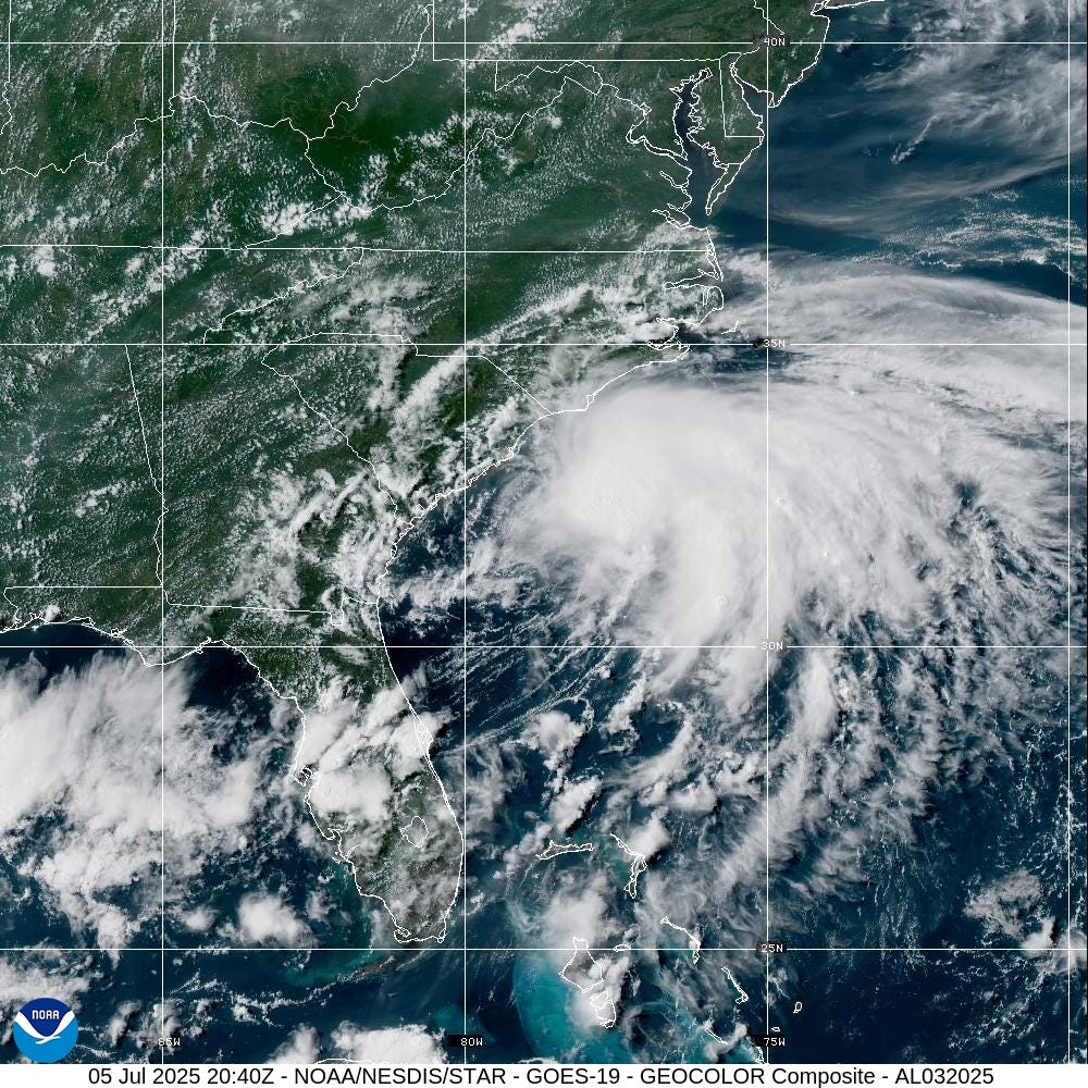
Tropical Depression 3 has intensified into Tropical Storm Chantal, according to the National Hurricane Center. As of Saturday, July 5, at 5 p.m., the storm was located approximately 95 miles southeast of Charleston, South Carolina, with maximum sustained winds of 45 mph and higher gusts. Forecasters predict that Chantal’s peak sustained winds could reach up to 50 mph before it makes landfall, though most of the stronger winds are expected to remain over the Atlantic Ocean, offering some relief to the coastal Carolinas.
Chantal is moving northward at a speed of 7 mph. A shift to a north-northwest direction is anticipated later in the evening, with the storm's center expected to cross the coast of South Carolina overnight or early on Sunday. Tropical storm conditions are likely to begin in parts of the coastal Carolinas this evening and continue through Sunday morning.
A tropical storm warning is currently in effect from South Santee River, South Carolina, to Surf City, North Carolina. Additionally, a tropical storm watch has been issued for Edisto Beach to South Santee River, South Carolina. Conditions within these areas are expected to worsen over time.
Heavy rainfall is anticipated across portions of the Carolinas through Monday, with storm totals ranging from 2 to 4 inches and local amounts reaching up to 6 inches. This rainfall increases the risk of flash flooding, particularly in urban areas. Isolated tornadoes may also occur tonight and Sunday across parts of eastern South Carolina and eastern North Carolina.
Current Location and Movement of Tropical Storm Chantal
As of 5:00 p.m. on July 5, the center of Tropical Storm Chantal was located near latitude 31.9 North and longitude 78.7 West. The storm is moving toward the north at 7 mph, with an expected shift to a north-northwest direction later in the evening. By Sunday night, the storm is forecast to turn northeast.
On its current path, the center of Chantal is expected to move across the coast of South Carolina overnight or early Sunday morning. Maximum sustained winds are currently near 45 mph, with higher gusts. Some slight strengthening is expected before landfall, followed by rapid weakening after the storm moves inland.
Tropical-storm-force winds extend outward up to 140 miles primarily to the east of the center. The storm is about 95 miles southeast of Charleston, South Carolina, and 165 miles south-southwest of Wilmington, North Carolina. The pressure associated with the storm is recorded at 1006 MB.
Watches and Warnings
A Tropical Storm Warning is in effect for South Santee River, SC, to Surf City, NC. A Tropical Storm Watch is active for Edisto Beach to South Santee River, SC. A warning indicates that tropical storm conditions are expected within the area, typically within the next 12 to 24 hours. A watch means that such conditions are possible, generally within 48 hours.
Residents along the southeast coast should monitor the storm's progress closely. For specific information about the storm in your area, including potential inland watches and warnings, it is recommended to check updates from your local National Weather Service office.
Key Messages and Hazards
Tropical storm conditions are expected to begin in the warning area this evening and continue through Sunday morning. Heavy rainfall across the Carolinas will lead to elevated risks of flash flooding through Monday, especially in urban regions. Chantal is also expected to bring life-threatening surf and rip currents along the coast from northeastern Florida to the Mid-Atlantic states during the next day or so. Beachgoers should follow the advice of lifeguards and local officials.
Wind, Rainfall, and Storm Surge
- Wind: Tropical storm conditions are expected in the warning area beginning this evening and continuing through Sunday morning. Possible conditions in the watch area are expected this evening and overnight.
- Rainfall: Heavy rainfall is expected across parts of the Carolinas, with storm totals ranging from 2 to 4 inches and local amounts up to 6 inches. This can lead to flash flooding.
- Storm Surge: The combination of storm surge and tide could flood normally dry areas near the coast. Water levels could reach 1 to 2 feet above ground in areas from Edisto Beach, SC, to Surf City, NC, if the peak surge occurs at high tide.
- Tornadoes: Isolated tornadoes may occur tonight and Sunday across parts of eastern South Carolina and eastern North Carolina.
- Surf: Life-threatening surf and rip currents are expected along the coast from northeastern Florida to the Mid-Atlantic states.
Spaghetti Models and Forecast Trends
Spaghetti models, which show various forecast tools and models, are used by the National Hurricane Center to help make predictions. Only the top four or five highest-performing models are utilized for official forecasts.
The maximum wind speeds for Chantal are expected to fluctuate as follows: - 5 a.m.: 45 mph - 12 hours: 50 mph - 24 hours: 35 mph (inland) - 36 hours: 30 mph (post-tropical) - 48 hours: Dissipated
Updates and Resources
For real-time tracking of active storms in the Atlantic, an auto-updated graphic is available. If the storm trackers do not load, users can click here for alternative access.
Additional resources include NWS radar for Florida on July 5, 2025, and a Florida rip current map for June 22, 2025. The National Hurricane Center introduced a new rip current risk map for the 2025 season, providing daily and composite risk assessments for coastal areas.
About the 2025 Hurricane Season
The Atlantic hurricane season runs from June 1 through November 30. Ninety-seven percent of tropical cyclone activity occurs during this period, according to NOAA. The peak of the season is around September 10, with the most activity between mid-August and mid-October.
The Atlantic basin includes the northern Atlantic Ocean, Caribbean Sea, and Gulf of America (formerly known as the Gulf of Mexico). NOAA and the National Hurricane Center now use "Gulf of America" on maps and in advisories.
Staying Informed
To stay updated on weather alerts, consider signing up for text notifications. Interactive maps showing hurricanes and tropical storms that have affected your city are also available. Daily updates on tropical weather coverage will be provided, and downloading your local news site’s app ensures you stay connected.
For more information, visit special subscription offers and check out contributing reports from Dinah Pulver, USA TODAY.
Post a Comment for "Tropical Storm Chantal Intensifies: Florida Rain and South Carolina Landfall Expected"
Post a Comment